 sysop@mud2.com sysop@mud2.com
Yes, that's an e-mail address alright; "real soon now", if my Internet provider is to be believed, this address will become operational (in the meantime, my address is vttoth@vttoth.com.) And as the address indicates, this is my very own corner in our fabulous new newsletter. This is my place to ramble about things that may be of interest to the denizens of the Land.
This month I would like to talk about mapping. Mapping the Land was always one of my favourite subjects. Back when I was a new player on MUD1 (well, British Legends) I spent weeks trying to map the Land as accurately as possible. Many players believe that such detailed maps are not necessary, and it's enough to know (or perhaps, implement in the form of macros) a few key direction sequences, such as how to get from the hall of the cottage to the jetty for instance. My opinion is different; I believe that by methodically exploring every location, I was able to develop a much better mental view of the Land, not to mention that it also served as a guarantee that I wasn't missing an important clue to a puzzle or something. Indeed, by the time I made wiz, my maps were nearly perfect; the only locations I missed were ones that aren't accessible to mortals (and I even managed to map a few of those as well), and the only puzzles I didn't know were a few of the most obscure ones.
I think one of the reasons why mapping is considered difficult by many is that locations in the Land are not arranged in a nice, easy grid. Often, you may go northwest from one location to arrive at another, but when you go back southeast, you end up at a completely different place. No, this is not so because Richard missed his plane geometry classes in high school. The reason is that individual locations in the Land represent places that are of a different size. The South Pasture, for instance, is obviously a much larger place in terms of area than the Airing Cupboard. When such locations are next to each other, it is not unreasonable to expect that many directions from the smaller place lead to the larger one, but only a few (or one) of the directions from the larger place lead to the smaller.
Of course, there is another reason at work here; some areas are intentionally made more difficult to map because they represent a maze of sorts. These areas are characterised by many locations with the same description and seemingly illogical directions between them. The worst of these areas, rather unsurprisingly, is the swamp itself, with that fabulous crown in the middle that awaits the lucky (or patient) adventurer. Not only is it hard to map, it is different in every reset!
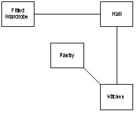
So how would you go about mapping the place? "Keep it simple, stupid" is one of my mottos! The technique I am about to describe is what I've been using ever since my first game of Zork, back in the days of steam-powered computers. What I do is I draw boxes, large enough to write the short description of a room into them, and use lines connecting the boxes to indicate directions of travel. Here is an example of four rooms from the cottage:
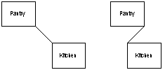
The direction that a line segment defines is determined by where the line connects with the box. Connecting at the middle of one of the sides is used to indicate a main direction (N, E, S, W); connecting at one of the corners is used to represent a secondary compass direction (NE, NW, SE, SW). It is important to note that the line itself may not be lying in the direction that it represents; for instance, the following two diagrams both indicate a NW-SE connection between the kitchen and the pantry:
Needless to say, you would be silly to use connections like that on the right side, as they can be very misleading. The trick to avoid having to resort to these is to leave enough space for all the rooms. Often, you place two rooms on your map only to find out that other rooms should really be placed in between these two, either horizontally, or vertically. Take, for instance, the hall and kitchen locations in the map fragment I showed first. Because the pantry is northwest of the kitchen, there has to be enough room between the hall and the kitchen vertically so that the pantry can fit in there. Otherwise it would interfere with the fitted wardrobe. If you realise that there isn't enough space in your map for a particular room, you may need to redraw your map. And this is exactly what I've done often; after an initial sketch, which allowed me to get a feel for the optimal placement of rooms, I created a second, and often a third, copy of my map until I got everything right.
This technique is all great, you say, but how does it address
the problem that I just mentioned, when travel between two
locations is not symmetrical? The answer is to use arrows
indicating directionality on a connection. I use a similar
technique to indicate that a connection represents up/down
travel; instead of an arrow, I place a small circular symbol,
half white, half black, on the line: ![]() .
.
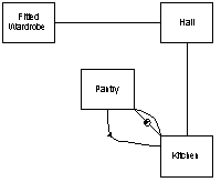
So what does the result look like? Here is the same set of four rooms, but this time with some secondary directions shown, one of them (moving southward from the pantry) one-way:
Why I have chosen this particular arrangement (instead of placing the pantry to the left of the fitted wardrobe, for instance) will become apparent when you see my completed map of the cottage area. But before we get to that, here are two points of advice that are very important to successful mapping.
To prove that this technique can really be used efficiently, here is a complete map of the cottage, including the cellar and small tunnel areas. I drew the first version of this map about 6 years ago, and I still have the priceless original, complete with coffee stains and cigarette burns (yes, I was still a smoker back then.) The present version was drawn using my favourite drawing application, VISIO, which, incidentally, has a feature that you may find very useful during mapping: it can be used to reposition objects while maintaining the connecting lines between them. Note that this drawing1 is rather largish, and may not fit on your screen unless you are using a fairly high resolution (1024x768 or better) video mode.
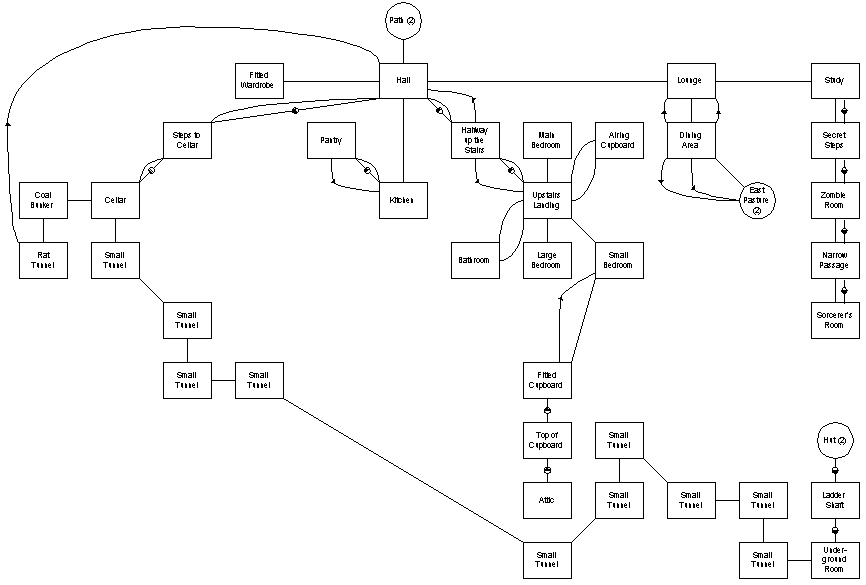
In case you are wondering, yes, I do have similar maps that cover all areas of the Land. Unfortunately, I am sad to report that they are not available for mortal consumption. Mapping the cottage is one thing ... finding your way through the dangerous passages in the mine or learning the shortcuts at the sea that can take you safely to the west shore without drowning are another matter altogether!
1Yes, there is indeed a place called "Rat Tunnel" in the Land. Where did you think all those rats are coming from? The first mortal who successfully reaches that place and sends me its long description is in for a prize!
This Web page copyright © 1997
Starquest & Viktor
|